Thorold Transit Complex - Year 1, 2021
The Niagara Region is no exception to the growth that is currently occurring in southern Ontario. The Provence of Ontario has forecast an increase in population by 168 000 for the region. This large increase in population opens the opportunity to improve the existing as well as create new infrastructure to support this growth. A challenge that will be face when moving people is the canal, we can only build so many bridges and tunnels.
A transit hub that is integrated with the shipping traffic of the Welland Canal may lead to a major opportunity to avoid road congestion, promote the use of public transportation, and stimulate the economy of the region.
Thorold Transit Complex
-

Main Multiuse Building
The Welland Canal has limited opportunities to cross by both road and rail. Although most of the crossings experience congestion when shipping traffic passes, St. Catharines traffic is the most impacted by shipping. The issue is twofold. Firstly, The Niagara Escarpment limits trucking traffic as the grades cannot be too large. This bottle necks trucking to certain roads, bridges, and tunnels. Secondly, the Welland Canal limits the amount of crossing available to road traffic further restricting the region's traffic's ability to move. Although the existence of the Welland Canal creates bottle necks and road congestion to the Niagara Region, it creates the unique opportunity for proposals. Improvements that are centralized to the Welland Canal may lead to crucial developments in integrated transportation in the Niagara region. One such improvement is the transit hub being built next to the canal with timed windows to work around shipping traffic.
-

Sidewalk and Staging Area Extension of the Platform
The primary location of the complex is on the East side of bridge six, although a secondary location can be considered along the Glendale Ave rail crossing. The area to the East side of the bridge is preferred for several reasons. Firstly, The primary location is centralized between major destinations. The complex is at the midpoint of Brock University and Niagara College as well as being just outside downtown Thorold. The complex being in the middle of these major destinations will maximize its servesous area reach. The centralized location is also surrounded by pre-existing infrastructure which will be easy to integrate into the complex. For example, Bus lines. St. Catherines has routes that cross the area, route 331, as well as the Niagara region Bus system, route 55. These routes can be marginally changed to serve the new complex. The primary location is also preferred because of the proximity to the rail corridor next to it. The rail corridor already carries passenger service by GO transit LakeShore West Line. With the station next to the rail line that is already being served by GO, the station can easily be added upon by “LakeShore West GO Expansion” that Metrolinx is planed to conclude by 2030.
-
Parking Area with Raised Pedestrian Walkway
The East of bridge six has a multitude of perks that makes it the preferred area for the complex. However, as a result of zoning law, the scope of the project will be limited by zone laws. The location is divided by two municipalities of St. Catharines and Thorold. As a result, the project will have to work with both municipalities zone laws. On Top of this, the area falls within the Niagara Escarpment Plan, shown in figure 2. More specifically, the area is classified as an Escarpment Protection Area, also known as an EPA. An EPA is areas of the Escarpment that have been significantly modified by human land use. In our case the several versions of the Welland Canal. The policies under an EPA are aimed to protect, maintain, and characterize the Escarpment. As a result of these limits, the scope of the complex must remain small enough to not further worsen the impact of human activity on the Escarpment. The smaller size will help prevent further damage to the environment, but further action must be taken. The area where the complex would be built, has been heavily modified by human activities. To fix and counteract the damage that has been done, A portion of the complex's profit and initial funding will go towards rejuvenation efforts.
-

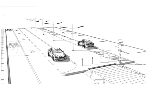
Platform
THE TRANSIT COMPLEX (in detail) A transit hub that suits the needs of the Niagara region poses unique challenges, as the region has unique needs. One of the regions needs is to reduce congestion, of which the complex has been designed to reduce. As stated in the introduction, the canal and the Niagara Escarpment bottleneck traffic, specifically trucking traffic, into certain routes. The new complex has been designed to prioritize the use of public transit, pedestrian and bicycles as modes of transportation. The complex has a dedicated bus and bike lane with corresponding platforms. This opens the possibility for the complex to act as a transit hub for the regions and promote the use of public transit. To further reduce congestion, several design choices have been made to promote pedestrian traffic. The largest method to promote pedestrian traffic is to increase the safety of the complex. This is achieved by: The complex having clear line marks to direct traffic in which way to flow and stop. Elevated crosswalks to improve the visibility of pedestrians to vehicular traffic and increase motorist awareness of the cross walk
Utilizing pedestrian controlling crossing lights to indicate to bicycles when to stop. Brick barriers between “shared space areas” and “pedestrian only” areas. All areas are lit with LED lights. To reduce the traffic congestion for the region's projected growth, this new complex promotes the use of public transportation and pedestrian traffic to reduce the demand on the region's infrastructure. The dedicated bus lane and the abundance of safety features to protect pedestrians will improve passenger experience with public transportation and promote the use of alternate modes of transportation. Although the complex is designed to promote safety, the cosmetics of the structure are not sacrificed.
-

Isometric Projection
CONCLUSION AND FUTURE CONSIDERATIONS
The Welland Canal has limited opportunities to cross by both road and rail. Although most of the crossings experience congestion when shipping traffic passes, St. Catharines traffic is the most impacted by shipping. As the region population increases, traffic congestion for the impacted by shipping will continue to limit the region's ability to move. A proposed transportation complex next to the canal will promote alternate modes of transportation as well as lower the impact of shipping by use of traffic windows.